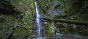
With trail statistics that looked easy on paper, and a waterfall that is little known except by the locals, my expectations were pretty low. What a pleasant surprise this hiked turned out to be!
Even though The Forest of Nisene Marks State Park is listed as undeveloped in many publications, majority of this hike is well maintained and well marked. It only becomes challenging at the very last 0.5 miles, as you will find out later in this guide.
The trailhead parking is comically small, so most people will park on the side of the road. On weekends, when these spots fill up, rangers will close the road completely and you will have to park near the park entrance and walk in. Even though the extra walk is easy and pleasant, it will add approximately 1.1 mile EACH WAY to your hike. So arrive early or arrive later in the afternoon to avoid the crowd.
Begin the hike by continuing on the fire road you drove in on, walk past the steel bridge that spans a gorgeous canyon. Beyond the bridge, there is a locked gate. (In the summer, you may be able to drive further if you are a registered camper.) The road is fully shaded and flat, a very easy walk.
360 VR Trail Views
As you continue on, the trail narrows and you will come to a junction with a sign and a chair nearby. You will take the trail on the left and begin a climb. The trail is the Aptos Creek Fire Road eventually leads you to the Loma Prieta Earthquake epicenter.
Trail Map
Trail Stats and Need to Know
LENGTH
10.03 mi
(16.14 km)
TYPE
Lollipop Loop
HIKING TIME
4.5 hr
ELEV GAIN
1410 ft
(430 m)
ELEV LOSS
1410 ft
(430 m)
MAX ELEV
845 ft
(258 m)
MIN ELEV
167 ft
(51 m)
- Well maintained trail with a nice moderate grade until the last 0.5 mile.
- Almost the entire trail is shaded.
- Small but elegant waterfall.
- Challenging to find parking on weekends.
- The last half mile might take you by surprise and can be quite physically demanding.
- Winter and spring is the best time to see the waterfall, but your shoes will almost certainly get wet.
Recommended footwear:
Trailrunner with good traction on sandy and wet surface.
Permits:
California State Park Pass.
Resources: